do you want to know How many districts in Manipur / Total district in Manipur ? 

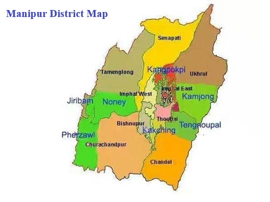
Manipur is a state in northeast India. Initially, Manipur only had 9 districts. However, in December 2016, the Manipur Cabinet announced the creation of 7 new districts in the state. As of 2023, there are a total of 16 districts in Manipur.

Churachandpur district is the largest district and Jiribam District is the smallest district  by area. Imphal West District is the most populated district in Manipur. 

also read about Population of Manipur

Manipur Districts List

# District Population (2011) Area (sq. km.) Density (persons/sq.km)
1 Bishnupur 237,399 496 479
2 Chandel 144,182 3,317 44
3 Churachandpur 274,143 4,574 60
4 Imphal East 456,113 710 643
5 Imphal West 517,992 519 998
6 Jiribam 43,818 232 190
7 Kakching 135,481  –  –
8 Kamjong 45,616 2,000 23
9 Kangpokpi  –  –  –
10 Noney  –  –  –
11 Pherzawl 47,250 2,285 21
12 Senapati 479,148 3,269 146
13 Tamenglong 140,651 4,391 32
14 Tengnoupal  –  –  –
15 Thoubal 422,168 514 821
16 Ukhrul 183,998 4,547 40

Source: Census 2011

also read about religion in Manipur

Manipur District Map

Manipur District Map

Largest and Smallest District in Manipur by Area

Churachandpur district covering an area of 4574 km² is the largest district in Manipur.  Jiribam District is the smallest district in Manipur with total area is 232 km²

# By AreaDistrictArea
LargestChurachandpur4574 km²
Smallest Jiribam232 km2

 Source: Census 2011

Largest and Smallest District in Manipur by Population

Imphal West District is the most populated district in Manipur. Its Population as per census 2011 is 5.18 Lakhs. Jiribam District with a population of 43818 is the least populated district in Manipur.

# by PopulationDistrictPopulation (Census 2011)
Most PopulatedImphal West517,992
LeastJiribam43,818

Highest and Lowest Population Density

Imphal West District ( 998 people per km) has the highest Population density in  Manipur. Pherzawl District with a population density of 21  people per km is the lowest-density district in Manipur.

# by DensityDistrictDensity (person/km)
HighestImphal West998
LeastPherzawl21

Source: Census 2011

Manipur District with Highest and Lowest Literacy rate

Imphal West district has the highest literacy rate in Manipur. Its literacy rate is 80.1%. Senapati District with a literacy rate of 63.06% is the least literate district in Manipur
 
# by Literacy RateDistrictLiteracy Rate
Most LiterateImphal West86.08%
LeastSenapati63.06%

Source: Census 2011

Manipur District with Highest and Lowest Male Female Ratio

Imphal West district (1031) has the highest Male-Female Sex ratio in Manipur. Chandel District (933) has the lowest male-female sex ratio in Manipur

# by Literacy RateDistrictSex ratio
HighestImphal West1031 females to 1000 males
LowestChandel933 females to 1000 males

Source: Census 2011

List of Districts in Manipur 2026 | Manipur District Map

Rajeev Rana

Rajeev Rana is an independent writer and researcher with a strong interest in history, population studies, and demographic trends in India and North America. He has been writing on demography-related topics for over five years, focusing on census data, migration patterns, ethnicity, and regional population changes. While not a formally certified demographer, Rajeev closely follows official data releases from government sources, census authorities, and reputable research institutions. His work aims to present complex demographic information in a clear, accessible, and neutral manner for readers seeking factual insights and broader context. Rajeev contributes to multiple informational websites and has particular familiarity with demographic and regional trends in the Delhi NCR region. His writing is driven by curiosity, data interpretation, and a commitment to accuracy rather than advocacy or opinion