> > India >> States >> Districts in India
do you want to know How many districts in MP / Total district in MP ?
Madhya Pradesh is a state in Central India. It’s the fifth most-populous state in India. As of 2023, there are a total of 52 districts in Madhya Pradesh. These districts are grouped into ten administrative divisions. Districts are subdivided into tehsils, of which there are 428 in Madhya Pradesh.
Chhindwara district is the largest district by area and Niwari District is the smallest district of Madhya Pradesh. Indore is the most populated district and Niwari District is the least populated district in Madhya Pradesh.
read about the Population of Madhya Pradesh
Madhya Pradesh Districts List
| # | District | Population (2011) | Area (km²) |
| 1 | Agar Malwa | 571278 | 2,785 |
| 2 | Alirajpur | 7,28,677 | 3,182 |
| 3 | Anuppur | 7,49,521 | 3,747 |
| 4 | Ashok Nagar | 8,44,979 | 4,674 |
| 5 | Balaghat | 17,01,156 | 9,229 |
| 6 | Barwani | 13,85,659 | 5,432 |
| 7 | Betul | 15,75,247 | 10,043 |
| 8 | Bhind | 17,03,562 | 4,459 |
| 9 | Bhopal | 23,68,145 | 2,772 |
| 10 | Burhanpur | 7,56,993 | 3,427 |
| 11 | Chhatarpur | 17,62,857 | 8,687 |
| 12 | Chhindwara | 20,90,306 | 11,815 |
| 13 | Damoh | 12,63,703 | 7,306 |
| 14 | Datia | 7,86,375 | 2,694 |
| 15 | Dewas | 15,63,107 | 7,020 |
| 16 | Dhar | 21,84,672 | 8,153 |
| 17 | Dindori | 7,04,218 | 7,427 |
| 18 | Guna | 12,40,938 | 6,485 |
| 19 | Gwalior | 20,30,543 | 5,465 |
| 20 | Harda | 5,70,302 | 3,339 |
| 21 | Hoshangabad | 12,40,975 | 6,698 |
| 22 | Indore | 32,72,335 | 3,898 |
| 23 | Jabalpur | 24,60,714 | 5,210 |
| 24 | Jhabua | 10,24,091 | 6,782 |
| 25 | Katni | 12,91,684 | 4,947 |
| 26 | Khandwa (East Nimar) | 13,09,443 | 7,349 |
| 27 | Khargone (West Nimar) | 18,72,413 | 8,010 |
| 28 | Mandla | 10,53,522 | 5,805 |
| 29 | Mandsaur | 13,39,832 | 5,530 |
| 30 | Morena | 19,65,137 | 4,991 |
| 31 | Narsinghpur | 10,92,141 | 5,133 |
| 32 | Neemuch | 8,25,958 | 4,267 |
| 33 | Niwari | 4,04,807 | 1170 |
| 34 | Panna | 10,16,028 | 7,135 |
| 35 | Raisen | 13,31,699 | 8,466 |
| 36 | Rajgarh | 15,46,541 | 6,143 |
| 37 | Ratlam | 14,54,483 | 4,861 |
| 38 | Rewa | 23,63,744 | 6,314 |
| 39 | Sagar | 23,78,295 | 10,252 |
| 40 | Satna | 22,28,619 | 7,502 |
| 41 | Sehore | 13,11,008 | 6,578 |
| 42 | Seoni | 13,78,876 | 8,758 |
| 43 | Shahdol | 10,64,989 | 6,205 |
| 44 | Shajapur | 9,41,403 | 6,196 |
| 45 | Sheopur | 6,87,952 | 6,585 |
| 46 | Shivpuri | 17,25,818 | 10,290 |
| 47 | Sidhi | 11,26,515 | 10,520 |
| 48 | Singrauli | 11,78,132 | 5,672 |
| 49 | Tikamgarh | 14,44,920 | 5,055 |
| 50 | Ujjain | 19,86,864 | 6,091 |
| 51 | Umaria | 6,43,579 | 4,062 |
| 52 | Vidisha | 14,58,212 | 7,362 |
read about religion in Madhya Pardesh
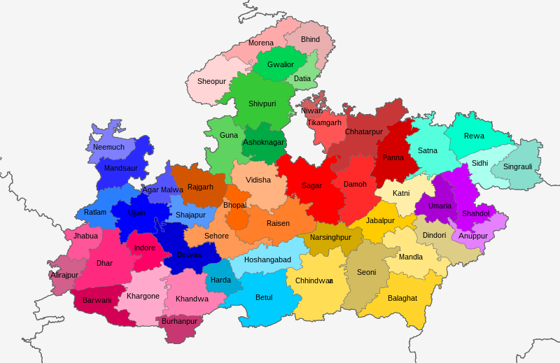
Madhya Pradesh District Map
Largest and Smallest District in Madhya Pradesh by Area
Chhindwara district covering an area of 11815 km² is the largest district of Madhya Pradesh. Niwari District is the smallest district of Madhya Pradesh with a total area of 1170 km²
| # By Area | District | Area |
| Largest | Chhindwara | 11815 km² |
| Smallest | Niwari | 1170 km2 |
Source: Census 2011
Largest and Smallest District in Madhya Pradesh by Population
Indore District is the most populated district in Madhya Pradesh. Its Population as per the census 2011 is 32.73 Lakh. Niwari District with a population of 404,871 is the least populated district in Madhya Pradesh.
| # by Population | District | Population (Census 2011) |
| Most Populated | Indore | 3,272,335 |
| Least | Niwari | 404,807 |
Highest and Lowest Population Density
Bhopal District (854 people per km) has the highest Population density in Madhya Pradesh. Dindori District with a population density of 94 people per km is the lowest-density district in Madhya Pradesh.
| # by Density | District | Density (person/km) |
| Highest | Bhopal | 854 |
| Least | Dindori | 94 |
Source: Census 2011
MP District with Highest and Lowest Literacy rate
| # by Literacy Rate | District | Literacy Rate |
| Most Literate | Jabalpur | 81.07% |
| Least | Alirajpur | 36.10% |
Source: Census 2011
MP District with Highest and Lowest Sex Ratio
Balaghat district (1021) has the highest Male-Female Sex ratio in Madhya Pradesh. Bhind District (837) has the lowest male-female sex ratio in Madhya Pradesh.
| # by Sex ration | District | Sex ratio (females to 1000 males) |
| Highest | Balaghat | 1021 |
| Lowest | Bhind | 837 |
Source: Census 2011
Know more about Madhya Pradesh