do you want to know How many districts in Mizoram / Total district in Mizoram ? 

Largest and Smallest District in Mizoram

Mizoram, nestled in the northeastern corner of India, is a state of unparalleled beauty and cultural richness. Bordered by Myanmar to the east and south, Assam to the north, and Manipur and Tripura to the west, Mizoram is characterized by its lush green hills, picturesque landscapes, and a tapestry of diverse indigenous cultures.

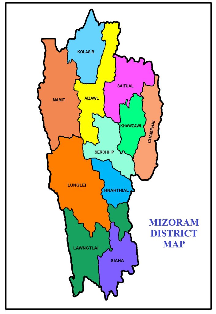
In the latest update as of 2024, Mizoram is administratively segmented into 11 districts, each contributing to the state’s overall governance and development. The districts serve as vital units for the implementation of government policies, ensuring that the benefits of progress and welfare reach every nook and corner of this enchanting state

also read about population of Mizoram

#DistrictPopulation (2011)Area (km²)
1Aizawl4,00,3093,577
2Champhai1,25,7453,168
3Hnahthial
4Khawzawl
5Kolasib83,9551,386
6Lawngtlai1,17,8942,519
7Lunglei1,61,4284,572
8Mamit86,3642,967
9Saiha56,5741,414
10Saitual
11Serchhip64,9371,424

*figures based on 2011 census, Hnahthial, Khawzawl & Saithual are formed after the 2011 census

also read about religion in Mizoram

Largest and Smallest District in Mizoram by Area

Lunglei district covering an area of 4572 km² is the largest district in Mizoram. Kolasin  District is the smallest district in Mizoram with a total area of 1386 km²

# By AreaDistrictArea
LargestLunglei4572 km²
Smallest Kolasib 1386 km2

 Source: Census 2011

Largest and Smallest District in Mizoram by Population

Aizawal District is the most populated district in Mizoram. Its Population as per census 2011 is 4 Lakhs  Saiha District with a population of 56754 is the least populated district in Mizoram.

# by PopulationDistrictPopulation (Census 2011)
Most PopulatedAizawal400309
LeastSaiha56574
Highest and Lowest Population Density

Aizawal District ( 113 people per km) has the highest Population density in Mizoram. Mamit District with a population density of 28  people per km is the lowest density district in Mizoram.

# by DensityDistrictDensity (person/km)
HighestAizawal113
LeastMamit28

Source: Census 2011

Mizoram District with Highest and Lowest Literacy rate

Serchhip district has the highest literacy rate in Mizoram. Its literacy rate is 80.1%. Lawngtlai with a literacy rate of 65.88% is the least literate district in Mizoram
 
# by Literacy RateDistrictLiteracy Rate
Most LiterateSerchhip97.91%
LeastLawngtlai65.88%

Source: Census 2011

Mizoram District with Highest and Lowest Sex Ratio

Aizawl district (1009) has the highest Male-Female Sex ratio in Mizoram. Mamit District (927) has the lowest male-female sex ratio in mizoram

# by Sex RaioDistrictSex ratio
HighestAizawl1009 females to 1000 males
LowestMamit927 females to 1000 males

Source: Census 2011

List of Districts in Mizoram 2026

Rajeev Rana

Rajeev Rana is an independent writer and researcher with a strong interest in history, population studies, and demographic trends in India and North America. He has been writing on demography-related topics for over five years, focusing on census data, migration patterns, ethnicity, and regional population changes. While not a formally certified demographer, Rajeev closely follows official data releases from government sources, census authorities, and reputable research institutions. His work aims to present complex demographic information in a clear, accessible, and neutral manner for readers seeking factual insights and broader context. Rajeev contributes to multiple informational websites and has particular familiarity with demographic and regional trends in the Delhi NCR region. His writing is driven by curiosity, data interpretation, and a commitment to accuracy rather than advocacy or opinion