> > India >> States >> Districts in India
do you want to know How many district in Assam/ Total district in Assam ?
Nestled in the northeastern corner of India, Assam stands as a captivating state renowned for its lush landscapes, diverse cultures, and historical significance. As the largest and most populous state in the northeastern region, Assam plays a pivotal role in shaping the socio-cultural and economic dynamics of this part of the country. As of the latest available information in 2024, Assam is administratively organized into 31 districts, each contributing to the state’s rich tapestry of traditions, ethnicities, and developmental aspirations. The majority of the newly constituted districts are sub-divisions of the earlier districts.
The merger of four District
The Assam government on the 31st Dec 2022 decided to merge four districts with four others and changed the administrative jurisdiction of a few villages. Biswanath district will be merged with Sonitpur, Hojai will be merged with Nagaon, Bajali will be merged with Barpeta and Tamulpur will be merged with Baksa.
Source: https://assam.gov.in/
read about Population of Assam
Assam Districts List
The State of Assam is divided into 31 Administrative Districts. Tamulpur is the Newest district of the Indian state of Assam, carved out of the Baksa district. On 23 January 2022, Tamulpur was formally district was formally created.
| # | District | Population (2011) | Area (km²) | Density (/km²) |
| 1 | Baksa | 950,075 | 2,457 | 387 |
| 2 | Barpeta | 1,693,622 | 3182 | 532 |
| 3 | Bongaigaon | 738,804 | 1,093 | 676 |
| 4 | Cachar | 1,736,319 | 3,786 | 459 |
| 5 | Charaideo | 471,418 | 1,069 | 441 |
| 6 | Chirang# | 482,162 | 1,170 | 412 |
| 7 | Darrang | 928,500 | 1,585 | 586 |
| 8 | Dhemaji | 686,133 | 3,237 | 212 |
| 9 | Dhubri | 1,394,144 | 1,608 | 867 |
| 10 | Dibrugarh | 1,326,335 | 3,381 | 392 |
| 11 | Dima Hasao | 214,102 | 4,890 | 44 |
| 12 | Goalpara | 1,008,183 | 1,824 | 553 |
| 13 | Golaghat | 1,066,888 | 3,502 | 305 |
| 14 | Hailakandi | 659,296 | 1,327 | 497 |
| 15 | Jorhat | 924,952 | 2,851 | 324 |
| 16 | Kamrup | 1,517,542 | 3,105 | 489 |
| 17 | Kamrup Metropolitan | 1,253,938 | 1,528 | 821 |
| 18 | Karbi Anglong | 660,955 | 7,366 | 90 |
| 19 | Karimganj | 1,228,686 | 1,809 | 679 |
| 20 | Kokrajhar | 887,142 | 3,169 | 280 |
| 21 | Lakhimpur | 1,042,137 | 2,277 | 458 |
| 22 | Majuli | 167,304 | 880 | 190 |
| 23 | Morigaon | 957,423 | 1,704 | 562 |
| 24 | Nagaon | 2,823,768 | 3,973 | 711 |
| 25 | Nalbari | 771,639 | 2,257 | 342 |
| 26 | Sivasagar | 679,632 | 2,668 | 255 |
| 27 | Sonitpur | 1,924,110 | 3,176 | 606 |
| 28 | South Salmara-Mankachar | 555,114 | 568 | 977 |
| 29 | Tinsukia | 1,327,929 | 3,790 | 350 |
| 30 | Udalguri | 831,688 | 1,852 | 449 |
| 31 | West Karbi Anglong | 295,358 | 3,035 | 97 |
read about religion in Assam
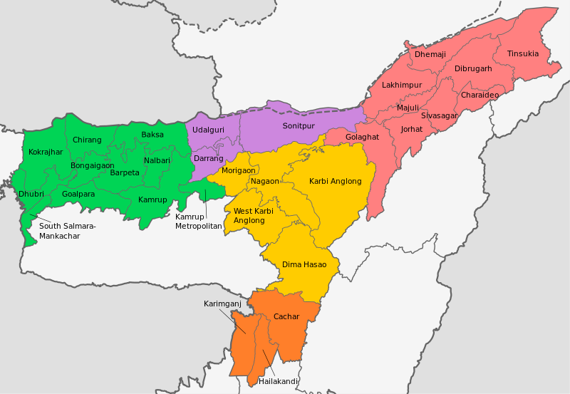
Assam District Map
Largest and Smallest District in Assam by Area
Karbi Anglong district, covering an area of 7366 km², is the largest district in Assam. South Salmara District is the smallest district in Assam, with a total area of 568 km²
| # By Area | District | Area |
| Largest | Karbi Anglong | 7366 km² |
| Smallest | South Salmara-Mankachar | 568 km2 |
Source: Census 2011
Largest and Smallest District in Assam by Population
Nagaon District is the most populous district in Assam. Its Population as per the census 2011 is 28.24 Lakhs. Majuli District, with a population of 1.68 Lakhs is the least populated district in Assam
| # by Population | District | Population (Census 2011) |
| Most Populated | Nagaon | 2,823,768 |
| Least | Majuli | 167,304 |
Highest and Lowest Population Density
South Salmara District ( 977 people per km) has the highest Population density in Assam. Dima Hasao District, with a population density of 44 people per km, is the lowest-density district in Assam.
| # by Density | District | Density (person/km) |
| Highest | South Salmara-Mankachar | 977 |
| Least | Dima Hasao | 44 |
Source: Census 2011
Assam District by Literacy rate
| # | District | Literacy rate |
| 1 | Bajali | 76.55% |
| 2 | Baksa | 69.25% |
| 3 | Barpeta | 50.97% |
| 4 | Bishwanath | 67.16% |
| 5 | Bongaigaon | 69.74% |
| 6 | Cachar | 79.34% |
| 7 | Charaideo | 75% |
| 8 | Chirang | 63.55% |
| 9 | Darrang | 63.08% |
| 10 | Dhemaji | 72.70% |
| 11 | Dhubri | 60.00% |
| 12 | Dibrugarh | 76.05% |
| 13 | Dima Hasao | 77.54% |
| 14 | Goalpara | 67.37% |
| 15 | Golaghat | 77.43% |
| 16 | Hailakandi | 74.33% |
| 17 | Hojai | 75.37% |
| 18 | Jorhat | 82.10% |
| 19 | Kamrup | 82.15% |
| 20 | Kamrup Metropolitan | 75.55% |
| 21 | Karbi Anglong | 70.80% |
| 22 | Karimganj | 78.22% |
| 23 | Kokrajhar | 65.22% |
| 24 | Lakhimpur | 77.20% |
| 25 | Majuli | 78.60% |
| 26 | Morigaon | 68.03% |
| 27 | Nagaon | 70.20% |
| 28 | Nalbari | 78.63% |
| 29 | Sivasagar | 84.23% |
| 30 | Sonitpur | 70% |
| 31 | South Salmara | 50.90% |
| 32 | Tinsukia | 69.66% |
| 33 | Udalguri | 65.41% |
| 34 | West Karbi Anglong | 69.30% |
Source: Census 2011
Assam District by Sex Ratio
Baksa district (974 ) has the highest Male-Female Sex ratio in Assam. Dima Hasao District (932) has the lowest male-female sex ratio in Assam.
| # | District | Sex Ratio |
| 1 | Bajali | 974 |
| 2 | Baksa | 974 |
| 3 | Barpeta | 932 |
| 4 | Bishwanath | 970 |
| 5 | Bongaigaon | 966 |
| 6 | Cachar | 959 |
| 7 | Charaideo | 958 |
| 8 | Chirang | 969 |
| 9 | Darrang | 954 |
| 10 | Dhemaji | 953 |
| 11 | Dhubri | 950 |
| 12 | Dibrugarh | 961 |
| 13 | Dima Hasao | 932 |
| 14 | Goalpara | 964 |
| 15 | Golaghat | 964 |
| 16 | Hailakandi | 951 |
| 17 | Hojai | 955 |
| 18 | Jorhat | 971 |
| 19 | Kamrup | 962 |
| 20 | Kamrup Metropolitan | 949 |
| 21 | Karbi Anglong | 952 |
| 22 | Karimganj | 963 |
| 23 | Kokrajhar | 959 |
| 24 | Lakhimpur | 968 |
| 25 | Majuli | 955 |
| 26 | Morigaon | 967 |
| 27 | Nagaon | 968 |
| 28 | Nalbari | 949 |
| 29 | Sivasagar | 954 |
| 30 | Sonitpur | 952 |
| 31 | South Salmara | 968 |
| 32 | Tinsukia | 952 |
| 33 | Udalguri | 973 |
| 34 | West Karbi Anglong | 954 |
Source: Census 2011
Know more about Assam