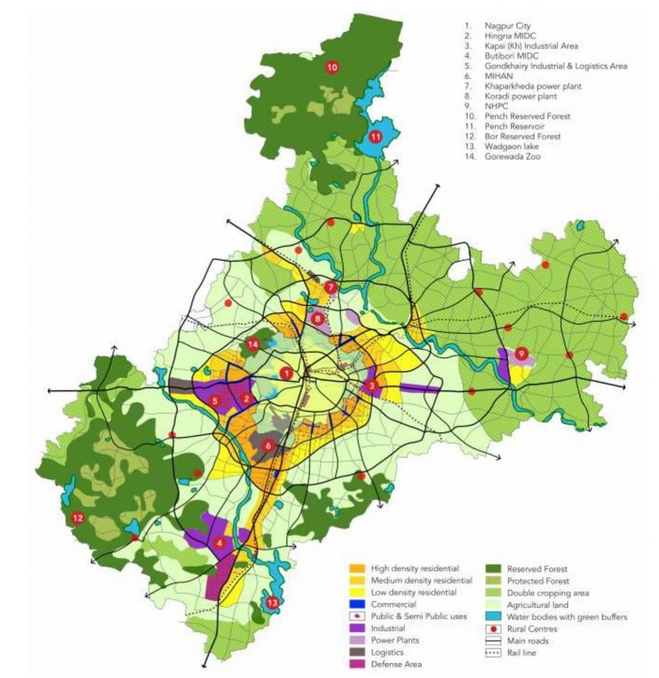
Nagpur is one of the largest cities in Central India and the third-largest city in Maharashtra after Mumbai and Pune. Nagpur Metropolitan Area (NMA) includes the Nagpur city & 721 villages under 9 tehsils of the Nagpur District spreading across an area of 3,567 km2.  Nagpur city area is 217.65 sq. km. & population of  20.52 lakhs. The average population density of Nagpur is 95 persons per ha. 

Nagpur is administered by the Nagpur Municipal Corporation (NMC). There are 10 zones in Nagpur – Laxmi Nagar, Dharampeth, Hanuman Nagar, Dhantoli, Nehru Nagar, Gandhi Baugh, Sataranjipura, Lakkadganj, Ashi Nagar, and Mangalwari. 

Map of  Nagpur is categorized & marked as following

  1. Residential – Yellow (Light Yellow for Low density & Dark Yellow for High Density)
  2. Commercial – Blue
  3. Industrial – Purple
  4. Magenta – Defense area
  5. Agriculture – light Green
  6. Rural Area – Red dots
  7. Greens (Reserved Forest, Protected Forest)
 

Map of Nagpur

Source: Nagpur Master Plan 2032

Nagpur Google Map

Map of Nagpur | Nagpur City – Divisions

Rajeev Rana

Rajeev Rana is an independent writer and researcher with a strong interest in history, population studies, and demographic trends in India and North America. He has been writing on demography-related topics for over five years, focusing on census data, migration patterns, ethnicity, and regional population changes. While not a formally certified demographer, Rajeev closely follows official data releases from government sources, census authorities, and reputable research institutions. His work aims to present complex demographic information in a clear, accessible, and neutral manner for readers seeking factual insights and broader context. Rajeev contributes to multiple informational websites and has particular familiarity with demographic and regional trends in the Delhi NCR region. His writing is driven by curiosity, data interpretation, and a commitment to accuracy rather than advocacy or opinion