do you want to know How many districts in Tripura / Total district in Tripura ? 

Nestled in the northeastern part of India, Tripura stands as a captivating state, steeped in history and surrounded by the lush landscapes of the region. Bordered by Bangladesh to the north, west, and south, and Assam to the east, Tripura is a land of cultural diversity, natural beauty, and a rich tapestry of traditions.

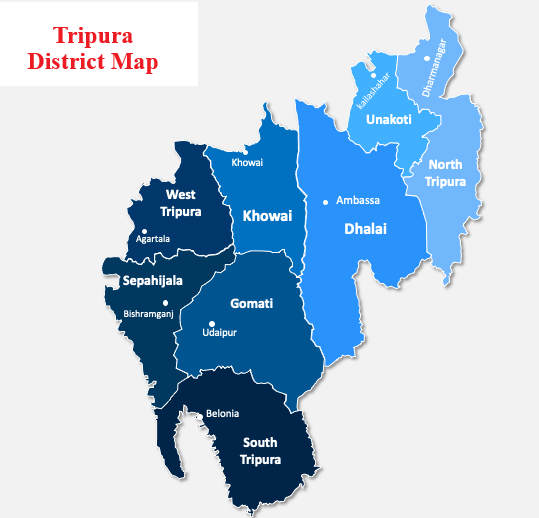
As of the latest available data in 2024, Tripura is organized into 8 districts, each playing a pivotal role in the governance and development of the state. These districts serve as administrative units, ensuring efficient implementation of policies and programs to cater to the needs of the local population and foster inclusive growth.

also read about Population of Tripura

Tripura District List

#DistrictPopulation (2011)Area (km²)Density (/km²)
1Dhalai3,77,9882,400157
2Gomati4,36,8681522.8287
3Khowai3,27,3911005.67326
4North Tripura4,15,9461444.5288
5Sepahijala4,84,2331044.78463
6South Tripura4,33,7371534.2283
7Unokoti2,77,335591.93469
8West Tripura9,17,534942.55973

also read about Religion in Tripura

Tripura District Map

Tripura District Map

Largest and Smallest District in by Tripura Area

Dhalai district covering an area of 2400 km² is the largest district in Tripura. Unokoti District is the smallest district in Tripura with a total area of 592 km².

# By AreaDistrictArea
LargestDhalai2400 sq. km
Smallest Unokoti592 sq. km

 Source: Census 2011

Largest and Smallest District in Tripura by Population

West Tripura District is the most populated district in Tripura. Its Population as per census 2011 is 9.18 Lakhs  Unokoti District with a population of 277335 is the least populated district in Tripura.

# by PopulationDistrictPopulation (Census 2011)
Most PopulatedWest Tripura917534
LeastUnokoti277335
Highest and Lowest Population Density

West Tripura District (973 people per km) has the highest Population density in Tripura. Dhalai District with a population density of 157  people per km is the lowest density district in Tripura.

# by DensityDistrictDensity (person/km)
HighestWest Tripura973
LeastDhalai157

Source: Census 2011

Tripura District with Highest and Lowest Literacy rate

West Tripura district has the highest literacy rate in Tripura. Its literacy rate is 88.70%. South Tripura with a literacy rate of 84.70% is the least literate district in Tripura.
 
# by Literacy RateDistrictLiteracy Rate
Most LiterateWest Tripura88.70%
LeastSouth Tripura84.70%

Source: Census 2011

Tripura District with Highest and Lowest Male Female Ratio

North Tripura district (967 ) has the highest Male-Female Sex ratio in Tripura.  Dhalai District (944) has the lowest male-female sex ratio in Tripura.

# by Sex RatioDistrictSex ratio
HighestNorth Tripura967 females to 1000 males
LowestDhalai944 females to 1000 males

Source: Census 2011

More Topics about Tripura

List of Districts in Tripura 2026 | Tripura District Map

Rajeev Rana

Rajeev Rana is an independent writer and researcher with a strong interest in history, population studies, and demographic trends in India and North America. He has been writing on demography-related topics for over five years, focusing on census data, migration patterns, ethnicity, and regional population changes. While not a formally certified demographer, Rajeev closely follows official data releases from government sources, census authorities, and reputable research institutions. His work aims to present complex demographic information in a clear, accessible, and neutral manner for readers seeking factual insights and broader context. Rajeev contributes to multiple informational websites and has particular familiarity with demographic and regional trends in the Delhi NCR region. His writing is driven by curiosity, data interpretation, and a commitment to accuracy rather than advocacy or opinion