> > India >> States >> Districts in India
do you want to know How many districts in Rajasthan / Total district in Rajasthan ?
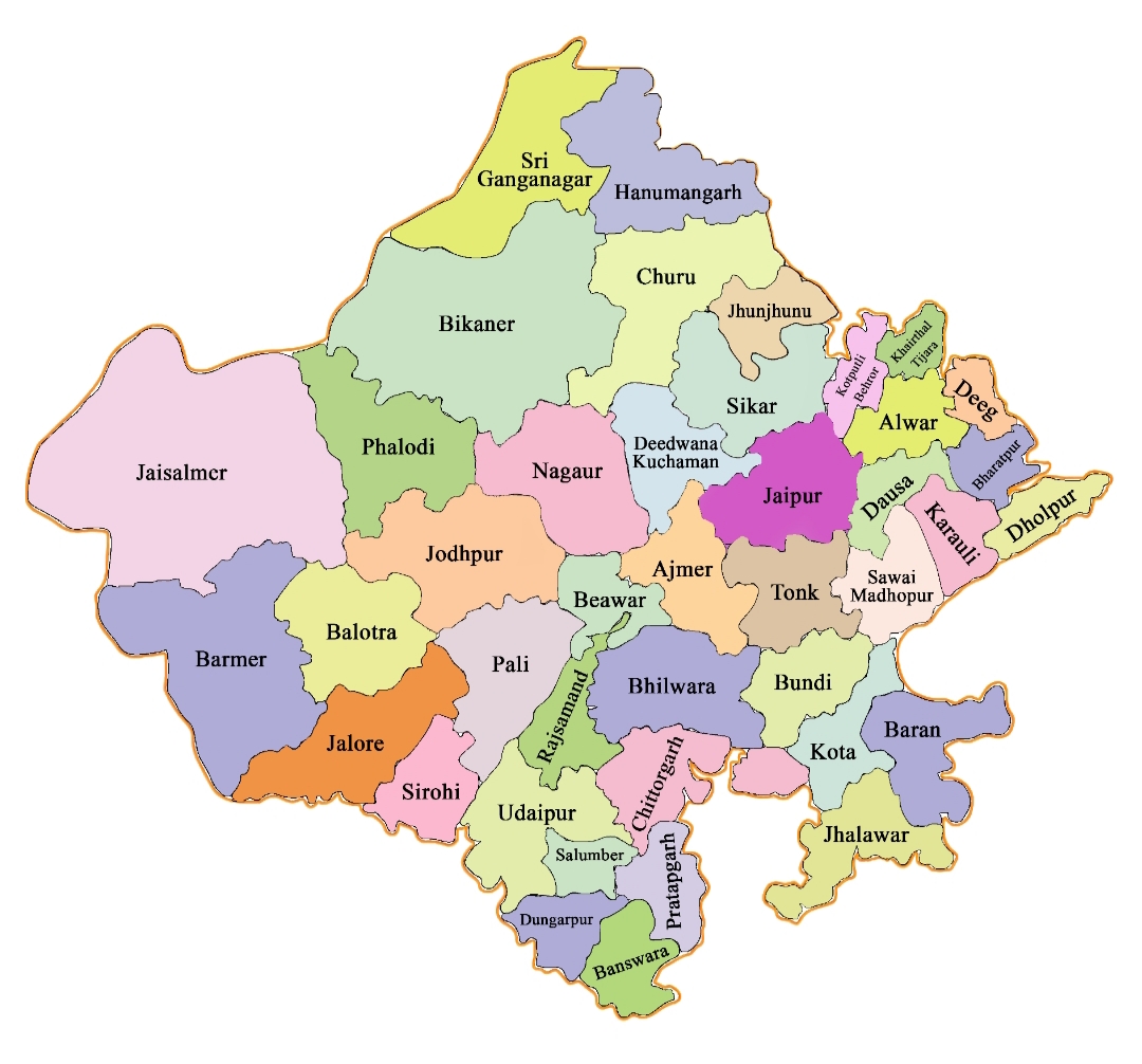
Rajasthan is a state in northwestern India. It is the largest Indian state by area and the seventh-largest by population. As of 2026, there are a total of 41 districts in Rajasthan.
Jaisalmer district is the largest district by area and Khairthal-Tijara District is the smallest district in Rajasthan. Jaipur District is the most populated district and Salumbar is the least populated district in Rajasthan.
read about Population of Rajasthan
Rajasthan Districts List
| # | District | Population | Area (km²) | Density |
| 1 | Ajmer | 1,531,974 | 8,481 | 180.64 |
| 2 | Alwar | 2,015,275 | 8,380 | 240.49 |
| 3 | Balotra | 1,115,751 | 19,000 | 58.72 |
| 4 | Banswara | 1,798,194 | 5,037 | 357.00 |
| 5 | Baran | 1,223,921 | 6,992 | 175.05 |
| 6 | Barmer | 1,488,000 | 28,387 | 52.42 |
| 7 | Beawar | 1,094,918 | 8,481 | 129.10 |
| 8 | Bharatpur | 1,475,707 | 5,066 | 291.30 |
| 9 | Bhilwara | 1,589,543 | 10,455 | 152.04 |
| 10 | Bikaner | 2,367,745 | 30,247 | 78.28 |
| 11 | Bundi | 1,113,725 | 5,550 | 200.67 |
| 12 | Chittorgarh | 1,544,392 | 7,822 | 197.44 |
| 13 | Churu | 2,041,172 | 13,858 | 147.29 |
| 14 | Dausa | 1,637,226 | 3,432 | 477.05 |
| 15 | Deeg | 1,072,755 | 2,169 | 494.59 |
| 16 | Dholpur | 1,207,293 | 3,084 | 391.47 |
| 17 | Didwana-Kuchaman | 1,625,837 | 6,796 | 239.23 |
| 18 | Dungarpur | 1,388,906 | 3,770 | 368.41 |
| 19 | Hanumangarh | 1,774,692 | 9,656 | 183.79 |
| 20 | Jaipur | 6,046,835 | 11,152 | 542.22 |
| 21 | Jaisalmer | 669,919 | 38,401 | 17.45 |
| 22 | Jalore | 1,828,730 | 10,640 | 171.87 |
| 23 | Jhalawar | 1,411,129 | 6,928 | 203.68 |
| 24 | Jhunjhunu | 2,137,045 | 5,928 | 360.50 |
| 25 | Jodhpur | 2,955,582 | 22,850 | 129.35 |
| 26 | Karauli | 1,458,248 | 5,043 | 289.16 |
| 27 | Khairthal-Tijara | 966,821 | 2,007 | 481.72 |
| 28 | Kota | 1,951,014 | 5,217 | 373.97 |
| 29 | Kotputli-Behror | 1,271,426 | 2,920 | 435.42 |
| 30 | Nagaur | 1,605,543 | 17,718 | 90.62 |
| 31 | Pali | 1,605,543 | 12,387 | 129.62 |
| 32 | Phalodi | 731,583 | 9,408 | 77.76 |
| 33 | Pratapgarh | 867,848 | 4,117 | 210.80 |
| 34 | Rajsamand | 1,156,597 | 4,550 | 254.20 |
| 35 | Salumbar | 570,775 | 2480 | 230.15 |
| 36 | Sawai Madhopur | 1,335,551 | 10,527 | 126.87 |
| 37 | Sikar | 2,677,333 | 7,742 | 345.82 |
| 38 | Sirohi | 1,036,346 | 5,136 | 201.78 |
| 39 | Sri Ganganagar | 1,969,168 | 11,154 | 176.54 |
| 40 | Tonk | 1,421,326 | 7,194 | 197.57 |
| 41 | Udaipur | 2,497,645 | 11,724 | 213.04 |
Rajasthan District Map
Largest and Smallest District in Rajasthan by Area
Top 5 Districts by Area
Jaisalmer district covering an area of 38,401 km² is the largest district in Rajasthan.
| # | District | Area (km²) |
| 1 | Jaisalmer | 38,401 |
| 2 | Bikaner | 30,247 |
| 3 | Barmer | 28,387 |
| 4 | Jodhpur | 22,850 |
| 5 | Balotra | 19,000 |
Smallest Districts by Area
Khairthal-Tijara District is the smallest district in Rajasthan with a total area of 2,007 km².
| # | District | Area (km²) |
| 1 | Khairthal-Tijara | 2,007 |
| 2 | Deeg | 2,169 |
| 3 | Salumbar | 2480 |
| 4 | Kotputli-Behror | 2,920 |
| 5 | Dholpur | 3,084 |
Largest and Smallest District in Rajasthan by Population
Top 5 Districts by Population
Jaipur District is the most populated district in Rajasthan. Its Population as per census 2011 is 66.64 Lakhs.
| # | District | Population |
| 1 | Jaipur | 6,046,835 |
| 2 | Jodhpur | 2,955,582 |
| 3 | Sikar | 2,677,333 |
| 4 | Udaipur | 2,497,645 |
| 5 | Bikaner | 2,367,745 |
Smallest District by Population
Salumbar District with a population of 5.70 lakhs is the least populated district in Rajasthan.
| # | District | Population |
| 1 | Salumbar | 570,775 |
| 2 | Jaisalmer | 669,919 |
| 3 | Phalodi | 731,583 |
| 4 | Pratapgarh | 867,848 |
| 5 | Khairthal-Tijara | 966,821 |
Highest and Lowest Population Density
Jaipur District (542 people per km) has the highest Population density in Rajasthan. Jaisalmer District with a population density of 17 people per km is the lowest density district in Rajasthan.
| # by Density | District | Density (person/km) |
| Highest | Jaipur | 542 |
| Least | Jaisalmer | 17 |
Source: Census 2011
Rajasthan Districts by Literacy rate
| # | District | Literacy rate |
| 1 | Ajmer | 69.33% |
| 2 | Alwar | 70.72% |
| 3 | Banswara | 56.33% |
| 4 | Baran | 66.66% |
| 5 | Barmer | 56.53% |
| 6 | Bharatpur | 70.11% |
| 7 | Bhilwara | 61.37% |
| 8 | Bikaner | 65.13% |
| 9 | Bundi | 61.52% |
| 10 | Chittorgarh | 61.71% |
| 11 | Churu | 66.75% |
| 12 | Dausa | 68.16% |
| 13 | Dholpur | 69.08% |
| 14 | Dungarpur | 59.46% |
| 15 | Ganganagar | 69.64% |
| 16 | Hanumangarh | 67.13% |
| 17 | Jaipur | 75.51% |
| 18 | Jaisalmer | 57.22% |
| 19 | Jalore | 54.86% |
| 20 | Jhalawar | 61.50% |
| 21 | Jhunjhunu | 74.13% |
| 22 | Jodhpur | 65.94% |
| 23 | Karauli | 66.22% |
| 24 | Kota | 76.56% |
| 25 | Nagaur | 62.80% |
| 26 | Pali | 62.39% |
| 27 | Pratapgarh | 55.97% |
| 28 | Rajsamand | 63.14% |
| 29 | Sawai Madhopur | 65.39% |
| 30 | Sikar | 71.91% |
| 31 | Sirohi | 55.25% |
| 32 | Tonk | 61.58% |
| 33 | Udaipur | 61.82% |
*Census 2011 Date when we have only 33 Districts
Source: Census 2011
Rajasthan Districts by Sex Ratio
Dungarpur district (994) has the highest Male-Female Sex ratio in Rajasthan. Dholpur District (846) has the lowest male-female sex ratio in Rajasthan
| # | District | Sex Ratio |
| 1 | Ajmer | 951 |
| 2 | Alwar | 895 |
| 3 | Banswara | 980 |
| 4 | Baran | 929 |
| 5 | Barmer | 902 |
| 6 | Bharatpur | 880 |
| 7 | Bhilwara | 973 |
| 8 | Bikaner | 905 |
| 9 | Bundi | 925 |
| 10 | Chittorgarh | 972 |
| 11 | Churu | 940 |
| 12 | Dausa | 905 |
| 13 | Dholpur | 846 |
| 14 | Dungarpur | 994 |
| 15 | Ganganagar | 887 |
| 16 | Hanumangarh | 906 |
| 17 | Jaipur | 910 |
| 18 | Jaisalmer | 852 |
| 19 | Jalore | 952 |
| 20 | Jhalawar | 946 |
| 21 | Jhunjhunu | 950 |
| 22 | Jodhpur | 916 |
| 23 | Karauli | 861 |
| 24 | Kota | 911 |
| 25 | Nagaur | 950 |
| 26 | Pali | 987 |
| 27 | Pratapgarh | 983 |
| 28 | Rajsamand | 990 |
| 29 | Sawai Madhopur | 897 |
| 30 | Sikar | 947 |
| 31 | Sirohi | 940 |
| 32 | Tonk | 952 |
| 33 | Udaipur | 958 |
*Census 2011 Date when we have only 33 Districts
Source: Census 2011
Know more about Rajasthan
