> > India >> States >> Districts in India
do you want to know How many districts in Jharkhand / Total district in Jharkhand ?
Nestled in the eastern expanse of India, Jharkhand stands as a state with a distinctive identity, shaped by its rich cultural heritage, abundant natural resources, and a commitment to sustainable development. As the 15th largest state by area and the 14th largest by population, Jharkhand plays a pivotal role in the socio-economic fabric of the country. As of the latest available information in 2024, the state is administratively organized into 24 districts, each contributing uniquely to the vibrant tapestry of Jharkhand’s landscapes and communities.
West Singhbhum district covering an area of 72244 km² is the largest district by area and Ramgarh is the smallest district in Jharkhand. Ranchi District is the most populated district and Lohardaga is the least populated district in Jharkhand.
read about the population in Jharkhand
List of Districts in Jharkhand
| # | District | Population (Census 2011) | Area (Sq. km) | Density |
| 1 | Bokaro | 2,062,330 | 2,883 | 716 |
| 2 | Chatra | 1,042,886 | 3,718 | 275 |
| 3 | Deoghar | 1,492,073 | 2,477 | 602 |
| 4 | Dhanbad | 2,684,487 | 2,040 | 1,284 |
| 5 | Dumka | 1,321,442 | 3,761 | 300 |
| 6 | East Singhbhum | 2,293,919 | 3,562 | 648 |
| 7 | Garhwa | 1,322,784 | 4,093 | 327 |
| 8 | Giridih | 2,445,474 | 4,962 | 497 |
| 9 | Godda | 1,313,551 | 2,266 | 622 |
| 10 | Gumla | 1,025,213 | 5,360 | 193 |
| 11 | Hazaribagh | 1,734,495 | 3,555 | 403 |
| 12 | Jamtara | 791,042 | 1,811 | 439 |
| 13 | Khunti | 531,885 | 2,535 | 215 |
| 14 | Kodarma | 716,259 | 1,433 | 427 |
| 15 | Latehar | 726,978 | 4,291 | 200 |
| 16 | Lohardaga | 461,790 | 1,502 | 310 |
| 17 | Pakur | 900,422 | 1,811 | 498 |
| 18 | Palamu | 1,939,869 | 4,393 | 381 |
| 19 | Ramgarh | 949,443 | 1,341 | 684 |
| 20 | Ranchi | 2,914,253 | 5,097 | 557 |
| 21 | Sahibganj | 1,150,567 | 2,063 | 719 |
| 22 | Saraikela Kharsawan | 1,065,056 | 2,657 | 390 |
| 23 | Simdega | 599,578 | 3,774 | 160 |
| 24 | West Singhbhum | 1,502,338 | 7,224 | 209 |
read about religion in Jharkhand
Jharkhand District Map
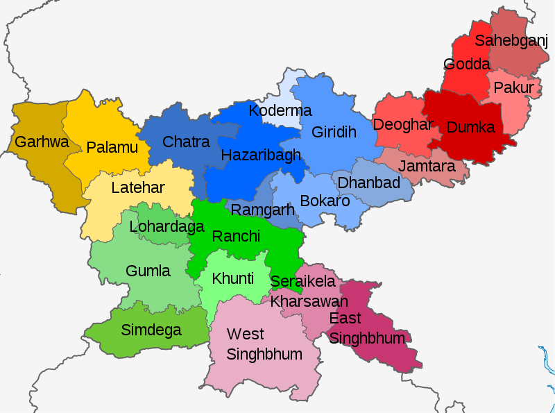
Source: Own work based on User:Milenioscuro, CC BY-SA 3.0, via Wikimedia Commons
Largest and Smallest District in Jharkhand by Area
West Singhbhum district covering an area of 7224 km² is the largest district in Jharkhand. Ramgarh District is the smallest district in Jharkhand with a total area of 1341 km².
| # By Area | District | Area |
| Largest | West Singhbhum | 7224 km² |
| Smallest | Ramgarh | 1341 km² |
Source: Census 2011
Largest and Smallest District in Jharkhand by Population
Ranchi District is the most populated district in Jharkhand. Its Population as per census 2011 is 29.14 Lakhs. Lohardaga District with a population of 4.61 lakhs is the least populated district in Jharkhand.
| # by Population | District | Population (Census 2011) |
| Most Populated | Ranchi | 2,914,253 |
| Least | Lohardaga | 461,790 |
Highest and Lowest Population Density
Dhanbad District (1284 people per km) has the highest Population density in Jharkhand. Simdega District with a population density of 160 people per km is the lowest density district in Jharkhand.
| # by Density | District | Density (person/km) |
| Highest | Dhanbad | 1284 |
| Least | Simdega | 160 |
Source: Census 2011
Jharkhand Districts by Literacy rate
Ranchi district has the highest literacy rate in Jharkhand . Its literacy rate is 76.06%. Pakur with a literacy rate of 48.42% is the least literate district in Jharkhand.
| # | District | Literacy rate |
| 1 | Bokaro | 72.01% |
| 2 | Chatra | 60.18% |
| 3 | Deoghar | 64.85% |
| 4 | Dhanbad | 74.52% |
| 5 | Dumka | 61.02% |
| 6 | East Singhbhum | 75.49% |
| 7 | Garhwa | 60.33% |
| 8 | Giridih | 63.14% |
| 9 | Godda | 56.40% |
| 10 | Gumla | 65.73% |
| 11 | Hazaribag | 69.75% |
| 12 | Jamtara | 64.59% |
| 13 | Khunti | 63.86% |
| 14 | Koderma | 66.84% |
| 15 | Latehar | 59.51% |
| 16 | Lohardaga | 67.61% |
| 17 | Pakur | 48.82% |
| 18 | Palamu | 63.63% |
| 19 | Ramgarh | 73.17% |
| 20 | Ranchi | 76.06% |
| 21 | Sahibganj | 52.04% |
| 22 | Seraikela Kharsawan | 67.70% |
| 23 | Simdega | 67.99% |
| 24 | West Singhbhum | 58.63% |
Source: Census 2011
Jharkhand Districts by Sex Ratio
West Singhbhum district (1005) has the highest Male-Female Sex ratio in Jharkhand. Dhanbad District (909) has the lowest male-female sex ratio in Jharkhand.
| # | District | Sex Ratio |
| 1 | Bokaro | 922 |
| 2 | Chatra | 953 |
| 3 | Deoghar | 925 |
| 4 | Dhanbad | 909 |
| 5 | Dumka | 977 |
| 6 | East Singhbhum | 949 |
| 7 | Garhwa | 935 |
| 8 | Giridih | 944 |
| 9 | Godda | 938 |
| 10 | Gumla | 993 |
| 11 | Hazaribag | 947 |
| 12 | Jamtara | 954 |
| 13 | Khunti | 997 |
| 14 | Koderma | 950 |
| 15 | Latehar | 967 |
| 16 | Lohardaga | 985 |
| 17 | Pakur | 989 |
| 18 | Palamu | 928 |
| 19 | Ramgarh | 921 |
| 20 | Ranchi | 949 |
| 21 | Sahibganj | 952 |
| 22 | Seraikela Kharsawan | 956 |
| 23 | Simdega | 997 |
| 24 | West Singhbhum | 1005 |
Source: Census 2011
Know more about Jharkhand
